On a clear day there are great views back to the west across the city skyline
About half way up the hill we pass the Anstey Hill water filtration plant that filters water from the Murray River brought in via the Adelaide/ Mannum pipeline.There is a little pullover section where you can get off the main road
And enjoy the views out past the storage tanks to Torrens Island Power Station and Outer Harbour
A little further up the hill a damaged fence on the right hand side of the road is a give away to the well used walking track that leads down to what is a very popular (but illegal) summer swimming location - the Highbury Quarry. Owned by Holcim Australia, (formerly Readymix) it was closed down in 1982.
Not much can be seen from the fence line
but a quick search on line shows what draws in the summer crowds!
 |
| (Tony Lewis/In Daily) |
In fact it wasn't too long ago (the last state election campaign) that the Liberal Party was spruiking the place as a whole new 350-hectare adventure tourism destination to be known as Crystal Lake Recreation Park. Needless to say, they lost the election and the whole plan was dumped by the Labor!
Not far past the quarry we hook off to the right down Paracombe Rd past Highercombe Golf and Country Club
There are a number of sweeping bends in the first section of this road with one passing by an interesting collection of pushbikes hanging on a fence. However, it's the large gum tree on the bend near the fence that highlights the dangers of driving and riding through the Adelaide Hills. This was the tragic site of a recent fatality when a ute hit this tree.
It's little wonder that someone lost their life
 |
| (ABC News) |
Once past the golf course we pass through Paracombe and the notice something that will be common on the day's ride - lot's of full dams! Not surprising as the hills in 2023 had the highest rainfall for June in over 20 years.
After passing Paracombe Oval we turn down Torrens Hill Rd and stop briefly to enjoy the views.
This road heads steeply downhill
and it is possible to glimpse down between the trees to see Gorge Rd snake along the edge of the Torrens River below.
Before the road reaches a T-junction at the bottom there is a fairly sharp bend that is another accident hotspot.
It was most recently the site of another fatality when a truck failed to take the corner and hit the tree
 |
| (7News) |
The T junction at the bottom is also a 'blackspot' as there is limited vision. As you turn left, keep a close eye on traffic (especially 'enthusiastic' street bikes) coming in from the right!
There are some nice sections of road that wind along the Torrens Gorge (this section is covered in a little more detail in the Mannum Bakery Ride). Soon we pass by Gorge Wildlife Park.
There are some grassy sections of river nearby
And then it's past the first of the two cafe's in Cuddle Creek.
Separated by a short section of road
It's then on to the more popular bike stop where "real food" is available!
After passing the cafe we veer away from the river off and head towards Lobethal on Cudlee Creek Rd
We begin passing the first of many covered orchards seen during our route through the hills
A few kms up the road we turn again, this time onto Fox Creek Rd. This passes by the Fox Creek Bike Park which contains over 50kms of single track mountain bike trails (they should be so lucky 😀)
After a hairpin bend the road heads uphill through a few snakey bends
This area was smashed by the 2019 Cudlee Creek Fires but looking back to the north shows most of the vegetation has regrown.
A crest in the road comes up quickly after the last bend and it's here that we leave the bitumen and turn right down Croft Rd
This winds it way along the the edge of the Fox Creek Bike Park and is where many of the downhill tracks start (a shuttle bus then runs back up from the lower carpark)
Opposite the top carpark sits Anderson Hill Winery a nice spot for lunch (when bakeries aren't the objective of the day!)
Croft Rd runs along the edge of the Cudlee Creek Forest Reserve which has just recently been logged.
Soon the turnoff to Mawson Rd is found hiding under the trees to the right (and I still often miss it!)
This is a nice section of road that runs alongside a mixture of native scrub
and pine plantations
which form part of the Coralinga Native Forest Reserve.
It's along this section that you will encounter a few spots where access to tracks in the forest is possible.
However, it seems that since the area has been logged the department is not keen on any entry!
To the east of this road there are extensive area of orchards - cherries, apples and pears.
Our next turn is down Blockers Rd
It's an interesting road that has a little 'Deliverance' feel about it.
If you're a Puegeot owner and looking for a spare part then you're in luck. There is a vast collection of wrecks lining the road with engines and gearboxes hanging in the trees
The road then snakes it's way down the edge of the gully
passing by some fire remnants
and rustic accommodation
before heading uphill and onto more conventional farming areas
A junction with Merchants Rd is reached at the bottom of the hill. It's a nice little ride along here as it follows Sixth Creek where a lot of work has been done to remove introduced plants and restore the creek surrounds but it ends in a locked gate a few kms down the road.
A little further on from that intersection several roads come together at the confluence of Sixth and Deep Creeks
We choose Burdetts Rd that heads up the hill
We choose Burdetts Rd that heads up the hill before meeting Lobethal and Range Roads along side the Basket Range WW1 memorial
Our route takes us across the intersection and down Range Rd then via a short section of Greenhill Rd until we pick up the dirt again on Gully Rd near Belfari Wines
Along here we get a glimpse of what it's like with your house surrounded by vines and orchards!
After a short run down Rangeview Drive
Mt George Rd is our next destination. Don't be tempted to try the enticing dirt track not far from the turn off on the right.. it leads to someones back yard!
Further on the road splits and we head up Muller Rd as Mt George Rd turns into a dead end
It's then on to Worden and Carey Gully Rd which takes us over the SE Freeway and into Bridgewater
We continue on past the Stirling cemetery and then pick up Nation Ridge Rd
It's then on to a short detour to check out the Aldgate Valley Reserve which is tucked in off Shanks Rd
A short entry track has a little cul-de-sac at the end by a tall gum tree. It's a good spot to park the bike, take a break and have a look around.
There's a short walk you can do
That leads to a bridge that crosses Aldgate Creek
It then heads down to the edge of the creek where you can get to the water
Once back on the bike we pick up Longwood Rd and head towards Heathfield until we turn off on Scott Creek Rd
It's then not far to our turn at Evans Rd which is easy to miss.
This is a great run through the northern section of Mark Oliphant Conservation Park.
That pops out in some open farmland before it reaches Ironbank Rd.

Our route takes us down Coat Rd which is hard to spot as it is right near the intersection of Ironbank Rd. This is the first of numerous roads on this ride (in different council areas) that have (relatively recently in some cases) had signs installed that try and discourage access (ie Fire Track Authorised Vehicles only, No Through Road, Road Closed, Local Traffic Only.. etc). For this ride I have checked them all on SA Gov websites and (all but one - more about that later) indicate that they are publicly accessible roads. However, some of those sites give conflicting information compared to what's on the ground (eg I have found council installed barriers on some roads in the state that SA Gov websites sites indicate are publicly accessible). So, I'm not advocating that you take these roads as there are always ways around but suggest you do your own research if necessary! What I would say is that if you choose to take these type of tracks then low speeds and consideration of protecting the track should always be a priority.

The first section of this track can get a little slippery but it then improves once past the adjoining farms.
We soon hook up with Ironbark Rd again and then make our way along Cherry Gardens Rd as we pass Blackwood Golf Club before turning off down Dorset Vale Rd. This takes us down past Scott Creek Conservation Park.
This whole area was part of a 2700 ha fire ground that was intentionally torched back in January 2021. The park itself was closed for over a year.
 |
| (Photo taken March 2021) |
Our next turn is onto Frith Rd which has a good quality gravel surface.
Until I found some wet sandy ground as a grader was working on the downhill section before it crosses over a creek
The last section of Frith Rd follows the edge of the Mt Bold Reservoir Reserve.
and is a good run through some native scrub land
it's then a steep decent down Potter Rd and into Clarendon where a quick stop for a hot drink (and maybe a donut 😀) is always an option!
With blood sugar levels increased we head off towards Mt Bold Reservoir. Rather than the direct route we turn off the Kangarilla Rd at Scenic Rd a few km down the road.
Then at the next intersection we head left up Quigley Rd (ignore the No Through Rd sign).
This takes us past some fine farm land where they've left lots of gums trees
that the locals seem happy about!
This section is a bit of a loop where we pick up Scenic Rd again (the northern section of Scenic Rd is now closed beyond this point)
It's then back to the main Mt Bold Rd
From there it's only a short run to the entrance and the main gate (which closes at 4pm)
Once past the gate and over the Onkaparinga River (the water source for the dam) the road splits and it becomes one way.
Soon the Reservoir is visible through the trees on the left
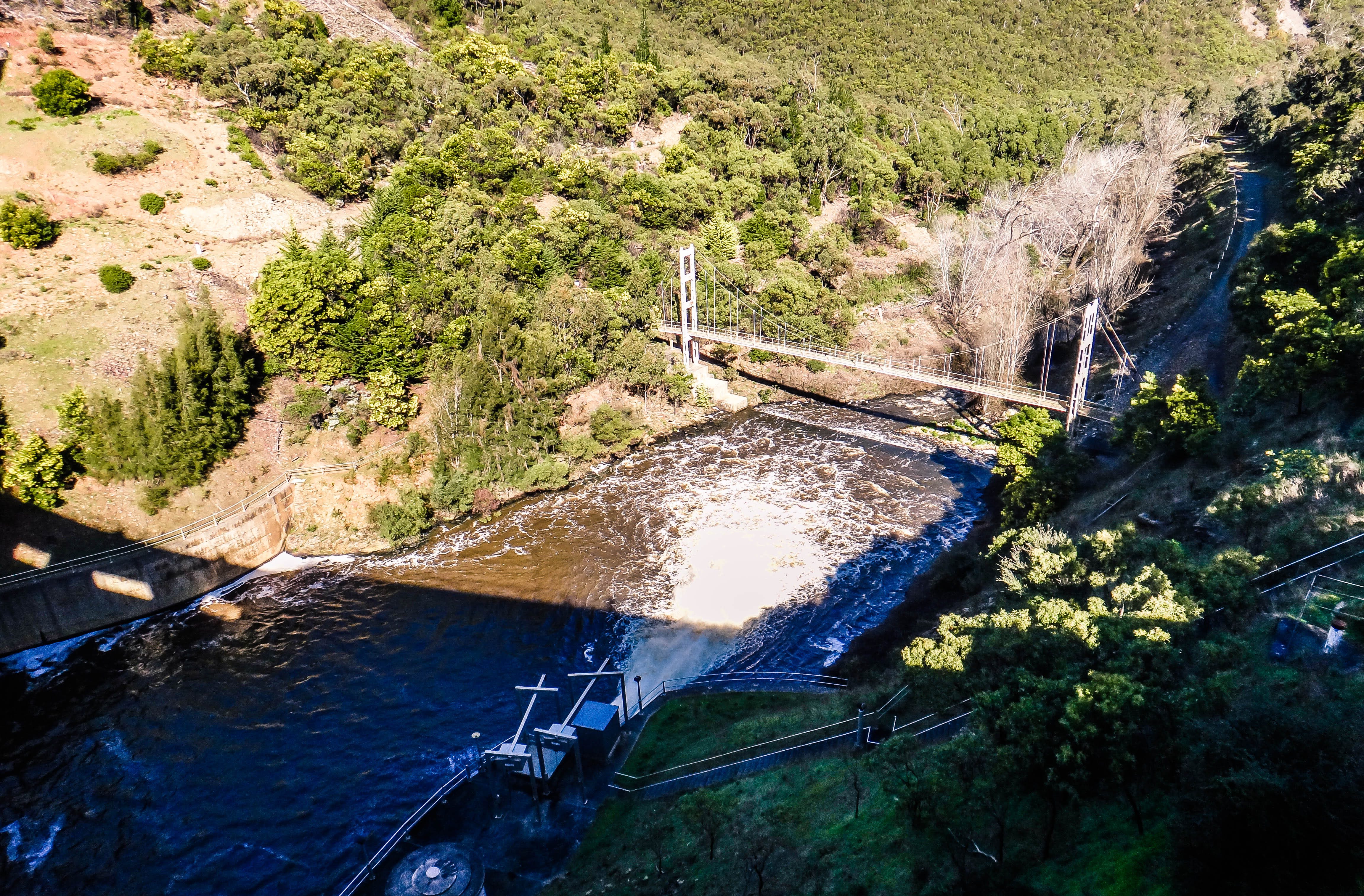
Before a car park near the dam wall is reached. The dam was built over six years and completed in 1938. It's SA's biggest reservoir with a capacity of over 46,000 megalitres.
From here you can walk along the top of the dam wall which is 192 m long and 52 m high
The swing bridge over the Onkaparinga river just downstream from the dam used to be accessible but access to the public is now restricted.
From the dam wall the one way road loops back to the entrance and then we are back on the Kangarilla Rd for a short spurt before turning off and heading up Saddlebags Rd
This is a great ride as it winds its way steeply up hill
until we reach Cut Hill Rd where we head off to the right
This winds it's way back down the hill and rejoins the Kangarilla Rd once more. We have one more little detour before lunch which takes us down Hillyfields Rd
At one point a track leads off to the left which runs between some paddocks and hooks back to Claren Rd. It was pretty muddy and it turns out to be part of the Heysen Trail but searches on line don't turn up any data on it's access permissions so you may choose to stick on Hillyfields Rd.
It's then just a short run into Meadows
Where we find our target bakery for the day - Pik-A-Pie!
The first thing that strikes you as you enter the bakery is the huge choice of different pastry products, including some rather exotic varieties (like salt and pepper squid pies!)
As a frequent visitor I've tried quite a few of their products but today's review was with a Chicken and Vegetable Pie. Here's how I scored it:
Pastry - Firm and tasty (with sesame seeds on top) 10/10
Filling - Plenty of flavour 10/10
Temperature - A tiny bit hot 9.5/10
Without spoiling future reviews Pik-A-Pie Bakery (Meadows) is probably my favourite bakery in SA. The food has always been of great quality (both pastry products and cakes etc) it has a huge range and it's very competitively priced!
The next section of the route heads south a few kms on Bull Creek Rd before ducking in to Nicole Rd.
There is a good view back out to the north along here where the newly developed housing can be seen on Meadows outskirts.
There is a short dead end track called Scowns Vista that may be worth a visit..
It tracks through the trees
Before ending at a gate, where a nice view out to the south is found.
Once back on Nicole Rd we weave among the trees.
Before passing another 'Fire Track Authorised Vehicles' only sign as Nicole Rd continues off to the left.
This section of Nicole Rd heads downhill and can be a little slippery as it follows a gully on the left.
It then weaves along a little before breaking through into more open farmland.
It ends at the intersection with Bull Creek Rd just after a small creek. As the junction is quite hidden, care needs to be taken when you pop out on the main road.
It's then a short run on the bitumen until the turn off on Spring Gully Rd. This crosses another creek
before it heads through some thick vegetation
From there it follows the gully upwards
It can get a little muddy in spots
with the occasional wash away and rut but it's never steep enough to be an issue.
As we near the peak of the road the green pastures spread out to the south.
It eventually meets up with Old Bull Creek Rd
We take a zig zag and end up following Blake Rd
Past some even greener paddocks, no doubt helped by the pivot irrigation system in place.
From there it's on to Shadygrove Rd, which ends up meeting up with the Macclesfield Rd.
It's then a short run into Macclesfield (Good pub here!)
As we head out of town the cows are now replaced with goats grazing in the paddocks


